Knapton’s Early History


So, let’s start with what we know…
Early settlements monument types in Knapton
- Field Boundary – unknown date
- Field System – unknown date
- Ring Ditch – unknown date
Aerial photography in 1976 and 1996 revealed the cropmarks of a ring ditch
A 1977 aerial photograph shows the cropmarks of ring ditches and field boundaries. - Trackway – unknown date
- Ring Ditch – Late Prehistoric
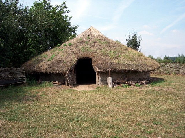
Cropmarks of field boundaries (presumably part of a field system), trackways and ring ditches are visible to the north and south of Knapton Road on NLA oblique aerial photographs taken by D A Edwards on 30th JUL 1977. The ring ditches might represent the remains of Bronze Age round barrows or prehistoric roundhouses. - Round House (domestic?) – Late Prehistoric
- Ring Ditch – Bronze Age
Aerial photography has revealed the cropmark of a ring ditch, possibly a Bronze Age burial mound - Round Barrow – Bronze Age
There are the probable remains of long since flattened burial mounds or barrows, only the marks of their surrounding ditches surviving. There are currently no Iron Age finds, but two square enclosure marks may be barrows from that time (NHER 13078).
- Roman finds recovered thus far include coins, brooches and pottery fragments
Metal detecting in February 1984 east of White House Farm recovered a Roman coin and a medieval (1066 to 1539AD) coin (NHER 20181)
Roman finds recovered thus far include coins, brooches and pottery fragments
Metal detecting in February 1984 east of White House Farm recovered a Roman coin and a medieval coin (NHER 20181)
(NHER 20181, 23337 and 32326), Several cropmarks on aerial photographs have been interpreted as being Roman, including a possible farmstead (NHER 15911). Saxon finds consist of brooches and a ring (NHER 32326 and 36605).
Round Barrow
Late Neolithic and Early Bronze Age barrows tend to be roughly conical and cover usually one primary burial but also have secondary burials inserted into the mound later in the Early or Middle Bronze Age. Many round barrows had a circular surrounding ditch and bank but the form could vary greatly. It was common for subsequent ‘secondary’ burials to be inserted in and around these monuments, sometimes many years later. Round barrows are often found in conjunction with boundaries and it is unclear whether these existed when they were originally constructed or whether they formed a focus points when the boundaries were subsequently formed.
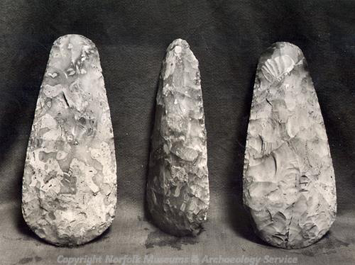
Neolithic Flint Axeheads
In 1950 a polished Neolithic axehead was discovered when a field close to the church was being ploughed up.
A late prehistoric piercer and prehistoric flint flakes were recovered while metal-detecting in 2010.
Three years later, in 1953, a hoard of seven flint axeheads were discovered in the same field.
An extract from the Norfolk County Website, Norfolk Heritage Explorer
1953. 14m (15 yards) from a spring 1.2km (3/4 of a mile) north of Parish Room.
Hoard of seven chipped flint axes found through deep ploughing. Three found in March 1953 and four more in October.
Site excavated by R. R. Clarke (NCM) on 25 October 1953 but nothing further found.
You can visit this page here.
Prehistoric Saddle Quern
Forty two years later, in 1995, a prehistoric Saddle Quern (a stone with a concave upper surface on which grain was ground by using a rubbing stone) was found, again by a plough, in the same field.
It is complete except for hole, possibly worn through it or plough damaged in a very thin area and can be dated between the Lower Palaeolithic (or Old Stone Age) to Late Iron Age, so somewhere between 500,000 BC to 42 AD.
Limoges Enamelled Plate
In 2007, while ploughing the field directly behind St Peter & St Paul’s Church, farmer Steve Hammond discovered a fascinating artefact. Steve sent the item away to ascertain it’s provenance and has been provided with the following information.
Gilt T-shaped :images enamelled plate, the upper terminal from the vertical arm of a large crucifix, worn and bent, with an engraved and enamelled depiction of a standing figure of Saint Peter, holding a book in his right hand and a key in his left hand. There are traces of white enamel on the face of the saint and dark blue enamel in the halo that has bordering concentric enamelled lines, the outer one white and the inner one red.
There are traces of dark blue enamel in the folds of the robe. The horizontal upper edge of the plate is interrupted by a semi-circular projection, the edge of which follows the outside of the edge of St Peter’s halo.
The angles between the horizontal and vertical elements of the plate are convex. The standing figure of the saint is flanked by a rectangular arrangement of four rivet holes piercing a gilt field, one to one side of both shoulders and one in both corners at his feet. The decoration on the field comprises lines of fine pecked dots within an engraved bordering line that contains fragments of pale blue or turquoise enamel. There is an engraved triangle in the centre of the upper part of the reverse 62 x (unbent) 75mm. Cf. terminal plaques illustrated in Enamels of Limoges 1100-1350 (1996), numbers 26, 62 and 67. Late 12th century.