Let’s look at Knapton’s timeline and see how we got here…

We look at artefacts that have been found and recorded, archaeological surveys that have been carried out, historical records dating from the Domesday Book to the current day and scholar writings etc as we seek answers to our questions such as;
who were our founding fathers… when was the first settlement created…

Neolithic Knapton

A late Prehistoric Round House, a Bronze Age Ring Ditch and a Round Barrow and more… from a later period we have found Roman coins, brooches ands pottery… the list goes on!

We take a deep dive into how we got here…

Our Saxon Heritage

In 2019, an Archaeological Survey of what is now the site of the Wilds Way estate was commissioned. It uncovered physical evidence of a settlement dating back to the late Saxon period, which is from 850AD to 1066AD.

We take a look at what was found and what it means…

” …archaeological remains across the eastern half of the site … define a truncated late Saxon and early medieval settlement phase with evidence of pits, postholes and ditches”

Architectural Solutions

So, it would appear that at around the same time that King Alfred was upsetting his host and burning the cakes, but around two hundred years before William got around to creating the Domesday Book, our ancestors were taking the first steps to creating the beginnings of a settlement that we know today as Knapton…

We take a look at the archaeological Survey that was commissioned by the developers before they put a spade in the ground.
The results finally gave reliable credence to both the idea that Knapton has been around longer than many villages around us, and the theories as to how it got its name.

quick link | Our Saxon Heritage
So, it probably all began on what was known as the Millennium Field, and is now known as Wilds Way, around 1200 years ago!

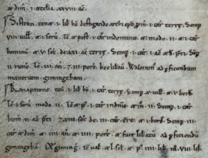
Whilst we don’t yet know the precise date of when the Saxon settlers first decided to build their home here, we do know that people have lived here for at least 1000 years because Kanapatone is mentioned in William the Conqueror’s Domesday Book of 1086, where it had an annual value to the lord of Sixty Shillings(£3).

Below we have shown a copy of the original manuscript and a translation.

Kanapatone Domesday Book entry
A photocopy from the Domesday Book for Kanapatone, Norfolk

You can visit the Open Domesday website and view / search the original folios of the Domesday Book by Anna Powell-Smith by clicking here.

Knapton is held by 1 free man (essentially rent-paying tenant farmer who owed little or no service to the lord) 1 carucate of land (a carucate was based on the area a plough team of eight oxen could till in a season). There have always been 10 villans (they rented land and were expected to spend some of their time working on the lord’s fields) and 5 bordars (holding just enough land to feed a family about 1 – 5 acres). Then [there was] 1 slave, now 2 (they had the fewest rights and benefits from the manor). Then and afterwards [there was] 1 plough in demesne, and now 2. There has always been 1 plough belonging to the men, 2 acres of meadow, and 13 sokemen (peasants with personal independence) carucates of land and 1 bordar. There have always been 3½ ploughs and 4 head of cattle and 4 pigs; and it was delivered to complete [the manor of] Gimingham. Gimingham then was worth 40s., and afterwards £4 now £8…

Our parish has a long history and was certainly well established by the time of the Norman Conquest in 1066, when Kanapatone was valued at 20 shillings, which was increased to 60 shillings in the seminal Domesday Book of 1086, perhaps due in part to the greater accuracy and thoroughness of that survey.

How much would 60s be worth today?

According to the National Archive’s Currency Converter, this could be equivalent to around £2,200 today.

What would it have bought then?

It’s not an exact science and there are lots of ifs and maybes, but back then, it would have bought, maybe, one of the following

  • three horses
  • eight cows
  • 23 stones of wool
  • 18 quarters of wheat
  • 300 days wages, for a skilled workman

So, back then it turns out that Knapton had 32 households, that was over twice as many as Mundesley (14), putting it in the largest 40% of the thirteen thousand settlements recorded in the Domesday Book.

Ancient history…

For a detailed look at our parish’s ancient history, which dates back to the Neolithic Period, we suggest that you visit the Norfolk Heritage Explorer website and start with the Knapton Parish Summary.

This site provides access to an abridged version of the Norfolk Historic Environment Record database online.
The Norfolk HER is the definitive database of the county’s archaeological sites and historic buildings and contains over 60,000 records describing the archaeology of Norfolk from the earliest evidence for human occupation from 750,000 BC right up to the present day.

It goes into great detail about the finds and discoveries that have been made within our parish and recommends further specific reading about them.

How did Knapton get it’s name?

The name of the Parish has long been the subject of many theories, but it is generally believed that it is of Anglo-Saxon origin and probably dates from the period of the Dane’s invasion, when they opted to settle in Norfolk, rather than just being regular visitors.

Walter Rye put forward a theory that several Norfolk village names reflected names in Scandinavia and in his History of Norfolk, published in 1885, he connected Knapton with Knappen in Eastern Denmark.

Scholars suggest it derives from two pre 7th Century Old English words, cnapa which meant boy or servant, and tun, which meant farm, enclosure or settlement. It’s possible that cnapa may also have been used as a personal name, so it’s likely that our village name originally meant Cnapa’s settlement or farm.

Recent history…

The parish has a long history and was certainly well established by the time of the Norman Conquest, when Knapatone was valued at 20 shillings, which was increased to 60 shillings in the seminal Domesday Book of 1086, perhaps due in part to the greater accuracy and thoroughness of that survey.

In his Portrait of Norfolk, David Yaxley notes that the village boundary with Paston…

… has hedges that date only from the 15th or 16th centuries, although the boundary itself goes back to before the Conquest

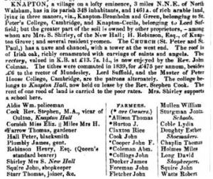
Things were different in 1845

William Whites History Gazetteer and Directory of Norfolk 1845
For a start, we had a shop…

The village was on a lofty eminence, covered an area of 1461 acres and had 348 inhabitants

We think they meant residents…
And we had our own Policeman, called Aldis.

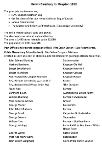
by 1911, a lot had changed

Then came the Telegraph Road…

Dire Straits indeed as the parish population has dropped to 346 but the area has grown to 1,490 acres, with a rateable value £2,680.

We’ve lost our Policeman, but gained a Station Master, a School Mistress, a Grocer, a blacksmith and a cattle dealer